The ‘jewel in the crown’ in the Cambrai/Sedan district is, without doubt, the Marne River. It has only a relatively small catchment area of some 238 square kilometres, surrounding the towns of Keyneton, Eden Valley and Springton, with the main stream flowing east. The catchment includes the Somme Creek (now renamed the North Rhine), which rises north of Keyneton and flows south to join the Marne roughly halfway between Eden Valley and Cambrai. This stream takes in approximately half of the total catchment area.
The Marne rises west of the Eden Valley to Springton road, at the crest of a gentle ridge, on the other side of which is the beginning of the Torrens River catchment.
The Somme falls from an elevation of 430 metres to the junction with the Marne, which falls some 500 metres from its catchment to the junction. The length of the River Marne to this point is 37 kilometres and from here on it drops 110 metres in 11 kilometres.
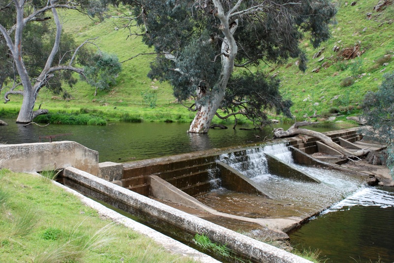
Between the junction of the two streams to where it breaks its way out of the ranges it flows through rugged gorges with savage twists and turns and sudden rockstrewn drops, the last feature being a beautiful gorge lined at the bottom with red gums and rocky outcrops. The entrance to this gorge is marked by a small disused weir a few kilometres south of Cambrai.

From here on the Marne flows gently to its destination, the River Murray. Much of its course meanders over a wide flat valley and flood plain, ever accompanied by stands of giant red gums. The lush flat ground forms a stark contrast to the semi-arid sides and high ground, which is marginal cropping and grazing country or patches of Mallee scrub land.
As by far the largest portion of the Marne water (in this stretch) flows underground, numerous farmers pump water from wells and bores to irrigate lucerne, the green crops adding to the lush appearance of this section of the river’s course.
A gravel road runs along the valley close to the river from where it breaks away from the hills, almost to its mouth at the Murray, so one can enjoy much of the scenic beauty from the luxury of a car. Unfortunately for those that don’t like to (or can’t) walk, the last section of the river is no longer followed by the road, so a very interesting stretch of the river can only be appreciated on foot.
At an old settlement marked on the map as Kongollia, the road crosses the river by means of a small bridge and shortly after this you pass the corner of the Marne Valley Conservation Park. The park is set at an angle to the road, so it touches only a corner. You can walk into it from here; but a much more spectacular entrance is gained if one takes the track that follows the ridge on the north side of the valley. You travel along this track until descending an incline to an intersection, where you can see the red gum forest on your right. Take the track down to the gums, get out and walk into the forest and you find yourself in a different world.
It’s only a small park but the forest within is, without doubt, the finest and most beautiful red gum forest close to Adelaide and, but for its size, compares with the best further up the Murray around Renmark. The cathedral-like trees can rejuvenate the soul as you stroll amongst them. Although at times the screeching cockatoos and galahs may be excessively loud, contrasting with the silent trees, ironically they add to the atmosphere and enhance the prevailing tranquility, perhaps by their contribution to the spirit of the forest.
The Marne flows through this forest and in wet years spills over and floods a low-lying area, forming a tranquil lagoon – a beautiful little lake studded with giant trees and surrounded by the remaining forest. It soon fills with water birds of various species and, in time, the ducks breed in the hollows of the flooded gums. Soon after, the lagoon has dozens of ducklings, scurrying after their mothers as the intruder approaches to see them.
However, there is a disadvantage during these wet times – one can’t walk through the forest. You have to content yourself with walking along the edge and looking in, you can no longer lose yourself amongst the magnificent trees and absorb their tranquility.
Further downstream the valley starts to narrow and although still accompanied by red gums, it starts to lose the lush appearance. The area takes on a different atmosphere and the river tends to become a mere channel. About here you pass through the town of Black Hill. Almost a ghost town, a sense of almost overpowering nostalgia descends upon those who are prone to tactile sensations.
Travelling on from Black Hill, the road crosses the Marne again, by means of a ford, to the north side, where the river puts on one last effort to throw off the sense of unease (almost depression) as the traveller comes to a small park-cum-picnic ground. There is a barbecue and a grotty little toilet, it’s a pretty spot nonetheless, with red gums lining the river which is now filled with reeds. The flat picnic area is carpeted with short sedge with vehicle tracks running through it. However, one can’t quite throw off the sense of alienation that prevails, or even be able to grasp exactly what it is.
Throughout this area are huge gullies of soft limestone, pitted with small caves and wombat burrows. Although a very dry area, the caves have been eroded out with water and inside hundreds of ancient marine fossils are exposed. These gullies also indicate the various levels of the sea as its level dropped and they have curious rounded tops and sides. They run down to the Marne and every one looks as though it would be interesting to walk up and explore.
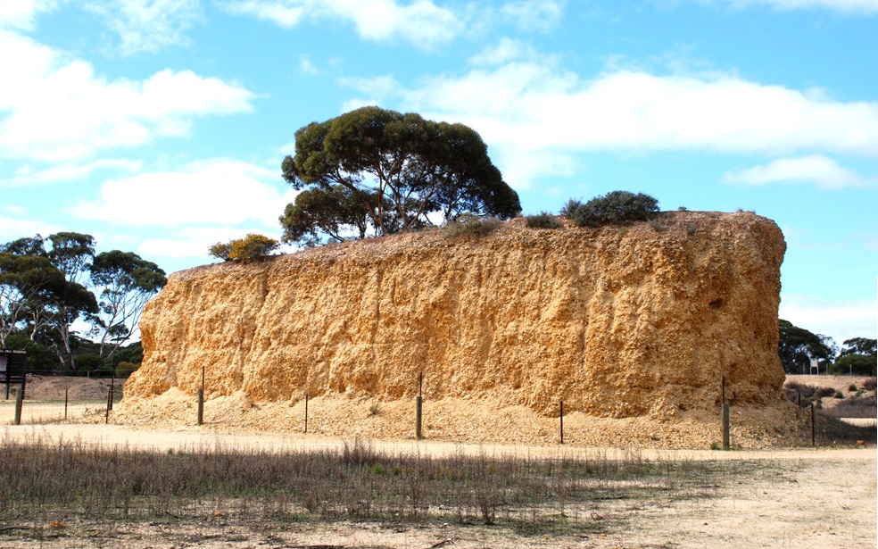
Just as the road starts to leave the river, which is now choked with reeds and dead trees, the traveller comes to a well-known landmark. Shell Hill was once a quarry, a huge hill of fossilised oysters, over five million years old and the largest of its type in the Southern Hemisphere. Before all the material was trucked away, someone must have realised the immensity of the vandalism of using ancient marine oysters as road material. A section about the size of a large house has been left. However, the vandalism continues; almost everybody who visits the remnants of Shell Hill takes away a few pieces of oysters as souvenirs.
After Shell Hill, the road to the mouth of the Marne leaves the river and doesn’t rejoin it until the traveller reaches Wongulla.


The mouth of the Marne is reached by driving as far upstream along the Murray as you can and then walking a short distance along a narrow peninsula that divides the two rivers. After scrambling over a few logs and pushing through some reeds, you are finally there. The great river on your right, the tranquil pools of the Marne on the left.
Rising above these pools is a ridge with the same rounded sides and top as the gullies mentioned before; contrasting with the sheer cliffs of the Murray. From here one gains a spectacular view of the two rivers and you can see a small section of what was missed by taking the road.
Sadly though, the Marne is dying. In 1982 an E&WS hydrographer wrote a report on ‘The impact of development on streamflow in the Marne River’. At that time it was estimated that an average of 20% of the flow was held back by the 500 dams in the catchment area. These dams were approximately 5 to 10 acres in surface area.
Today, the Marne no longer flows. It floods in extremely wet years, but there is no longer a yearly stream of water. With the boom in the wine industry, there are approximately 1500 dams with surface areas of 20 to 30 acres. To add insult to injury, areas in the catchment have been cleared of the red gums to make way for vines, despite this district having less than 2% of remnant native vegetation. So, what the lack of water is starting, salt will finish and there we have it – a paradise lost.
May – June 1999
